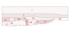
Unit 13 East Wall Profile
Originally uploaded by Port Tobacco Archaeological Project
The updating of maps continues. This week I am focusing on the profile drawings and getting them digitized using AutoCAD. Some of the drawings are very simple which makes it easy to recreate them on the computer. However, some (like the one pictured below) of the drawings are more complicated. One of the challenges I have encountered is in trying to decipher the drawings. This is due to the lack of continuity from drawing to drawing. Not all the drawings are complete and they were not all drawn using the same parameters. Since there was not one person overseeing the drawing phase, it is making for a bit more difficult time interpreting them. Not a big problem, just a step we could have avoided and will avoid next time.
Here’s a sample profile drawing without descriptions of each level. I will still do some tweaking of the drawings in AutoCAD to make them easier to see and to read.
The process for creating these in AutoCAD is fairly simple. The drawings are first scanned onto the computer. Next, those scanned images are imported into the existing map. Then we just trace the image onto the map.
Now that seems simple enough, right? Well, it is. There are a few other steps that we must do, like scaling the drawing to size, but over all that is the process.
Once all the drawings are in AutoCAD, we can then put them together to get full profiles of units and continuous walls through several units. I will post some images of these to the flickr site once they are done.
- Peter


No comments:
Post a Comment