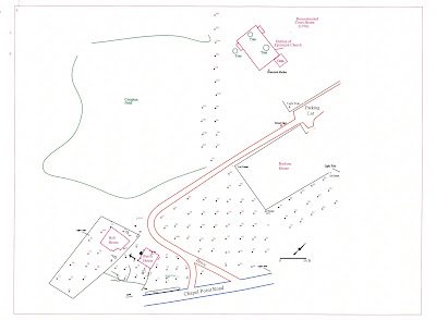
Just about every field day starts and ends with some survey work using the total station. This allows us to generate a relatively accurate map of our excavations and the buildings, fences, roads, trees, and other features and obstacles that exist at the site. The total station provides us with coordinates (north, east, and elevation) which we then use to draw the map using a software package called AutoCAD.
In the lab the site map helps us interpret and display our finds. In the field it helps us decide where to focus our day's efforts. The site map is also important as a record of our work so that future archaeologists, historic preservationists, planners, and site visitors will be able to identify the areas that have been excavated.
-April


2 comments:
After reading the blogs for the past week, I wanted the staff to know that I look forward to each day's posting.
As an Anthropology major from SUNY Potsdam in 1969 who was unable to work in my major, I am enjoying reading about the activities in Port Tobacco.
Thanks Ken!
Post a Comment